Here's some explanation on the use of runway-records in the editor.
Runways are not that difficult to create. You need the coordinates of the two ends, that's all :-) Convert these to the Fly system and set them in the Runway Latitude (High) and (Low) plus Runway Longitude (High) and (Low) lines. This will determine the runway heading, not what you specify in the Runway Magnetic/True Heading lines. Elevation can be left out, but my experience is that when you check in the Editor the elevation as given at the two ends and specify these values, at least sloping runways will be supported without ends sticking either into the air or going down under. Don't bend your runway around hilltops or across valleys, this will very likely not work :-)
You can set the two runway ends 10 miles apart, but the shown length will be that of the Runway Length line.
The record needs a key. Anything up to 10 characters will be OK. My suggestion is that you use letters and numbers only and perhaps the best identifier is the FAA or ICAO code with something added. Some people say "use your initials"... well, sooner or later more and more people are going to add new stuff and sooner or later some people might appear to share the same initials. Go figure...! Keys cannot be altered without messing up the whole database, so think ahead. I'll give an example:
Suppose JFK had NOT been included in the program. Now you start creating JFK. First comes the airport record. Call it KJFKAPT001. Next come the runways, IIRC JFK has 4 runways. Keys could be KJFKRWY01, 02, 03 and 04. Or KJFKRWY04L, 04R, 13L and 13R. Plenty of choice, and someone creating an additional runway at Karachi for sure won't come up with anything starting with KJFK...
Now we're talking about keys. You can use ILS-database keys like KJFKLOC22R, KJFKGS22R, KJFKOM22R for the individual components of any runway. The navaid key for the VOR then could be KJFKVOR01 or something. Adding a pure navigation VOR, let's assume Hartford? Make that HFD11490, like the identifier plus the frequency. Same goes vor NDB records. Use the F(ind) option to make sure a key has not been used before, if you still have doubts.
OK, we were talking about runways. You want a surface. Set the type and the condition of it to your liking (or to the known values). Pavement, PCN number and subgrade type are listed in airport FLIP's or simply make them up. You want an "overrun" on your runway? Set the displaced threshold value to the needed length. Next come da lites. I have another section on that stuff, follow the link at the bottom of this page..
Runway markings: some values don't work, like STOL or the Buoy markings. Some display different on different surfaces. I'll show you a few examples for bigger runways:
|
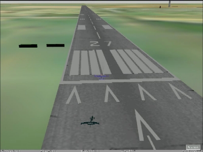
These are PIR markings on an asphalt runway, incl. a displaced threshold. Generally used for the bigger runways at major airports. |
|
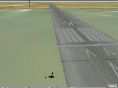
These are NPI markings on a concrete runway, again with a displaced threshold. Can be used for secondary bigger runways. |
It's easy to create a complete ILS system for a runway. You need to add records to the ILS database. One for the localizer system, another one for the GS system and if you want these, individual records for the markerbeacons and/or locator beacons. I have explained about the keys. The localizer is placed on the runway's centerline at or beyond the far end. The GS transmitter must be placed at the touchdown point, usually the location of the VASI or PAPI lights is good. What needs to be set correctly is the exact elevation of that point, you can find it in the Editor when you move to that specific point. If the value differs from the actual situation, your GS system will become unusable.
The localizer frequency needs to be a correct one; the GS transmitter always works, no matter what frequency you specify. The same is true for marker beacons, although the official frequency is 75.0 MHz. And of course the NDB frequency should be set OK. Ever tried a flight across Antarctica and discovered that the only NDB out there (Vostok) didn't work because some dummy left out the frequency in the record...?
![]()
Back to main Fly page
Page revised 20.09.2000